Biking the Danube -- Introduction
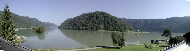
View of the Danube at Schlogen
Since I was a child and first heard the "Beautiful Blue Danube" waltz, I've had an image of the Danube river as romantic and beautiful, but I'm ashamed to say that I had never seen the Danube before this trip, taken in July 2004. The occasion to cycle down the Danube came about in conjunction with a meeting that my biking partner, Len Kleinrock, and I were to attend in Berlin. We looked around various maps and guide books for some biking trip that we could take in the vacinity of Berlin. What we wanted was a 250-mile stretch with interesting tourist attractions, such as enchanting small towns, and yet bike-friendly roads. We considered the well known "Romantic Road", with such delightful towns as Rothenburg and Dinkelsbuhl. It looked tempting, but I had toured this road previously, and was more inclined to find something new. We increasingly focused on the rivers in Germany. The Rhine is storied and has its famous castles, but the roads looked formidable there, and we kept coming back to looking at the Danube. Of course, though it begins in Germany, its best stretches are after the Austrian border. Finally, that was our choice.
We began the planning for the trip early in the year. Our previous bike trips in Europe, described elsewhere in this web site, were "roll-your-own" trips, where we did all the logistics and planning ourselves -- choosing the route, getting hotel reservations, and arranging for bikes. As we had learned, this can be quite time-consuming and complicated, but it always gave us a feeling of accomplishment. However, the Danube trip looked to be difficult to arrange this way, because the accommodations along the path are quite limited in the busy summer months and the tour operators book up most of the available rooms. Finally, we decided to book a self-guided tour with one of the companies that specialize in the Danube tour. We booked through an agent, Adventures on Skis, in Boston. The trip was handled by Rad & Reisen Eurocycle.
We had some misgivings about both the choice of the Danube route and the use of a packaged tour. In the following paragraphs I'll give our initial worries and how they turned out in reality.
Worries about the Danube Route
These were our initial worries: the trip was too easy, it was too crowded, and the scenery would be monotonously the same for the length of the river.
As it turned out, there was some small truth in each of these worries, but none was nearly as bad as we had anticipated. As for the path being easy -- there is no doubt that it is. It is advertised as completely flat, slightly downhill, and with the wind at your back as you bike east. What could be easier? However, I wouldn't say that it is completely flat. There are numerous ramps where there are short, moderately steep ramps rising 10 to 20 feet, and there are several steep climbs up to bridges. There is one day (of the six) when biking through the Wachau (wine-growing) region where the path leaves the river for moderate climbs among towns, orchards, and vineyards. But if you really want hills, take any of the recommended sightseeing excursions. If you want to visit a monastery, a castle, or a museum -- well, they are all perched high on hills overlooking the river.
As for being downhill -- the path descends a total of about 400 feet in the space of 230 miles. I'd call this flat. And I waited for the wind at my back, but for at least two of the six days that we cycled the wind was noticeably in our faces. For another three days there was seemingly no wind at all, and on one day we had a tail wind. We noticed a lot of bikers heading the opposite direction, i.e., west, but there is no doubt that most traffic does go west to east, because the tour operators truck the bikes back from Vienna to Passau.
I had read that the Danube bike path is very crowded in the summer months, and that since all riders start from the same intermediary points (the same hotels) at about the same time, there are traffic jams on the path. As it turned out, this worry was greatly exaggerated. The path was reasonably crowded, particularly near the towns on the weekends, but there were other long stretches when we wouldn't see another cyclist for perhaps ten minutes. We did get in "synch" with certain other small groups that we would encounter from time to time, but we never saw any of our own tour group after the first morning. About once an hour we would be passed, or would pass, a "peloton" of perhaps 20 to 30 cyclists, and every fifteen minutes or so a solitary biker, looking like he was doing the Tour de France, would pass us at great speed. On balance, I wouldn't have called the path particularly crowded.
As for the scenery being monotonous, I didn't find this to be the case. You can check the photos given here in the links to the descriptions of each day's travel. About half the path has a certain uniformity, where you are cycling alongside the river on a dedicated bike path. Ahead you see a castle perched on a hill on the opposite side of the river. A swan waits near the bank as you cycle by. On the opposite shore you see small, ant-like figures that are cyclists like you on the path across the river. It may have a sameness, but it also has a calming beauty.
Moreover, the path has more diversity than I had anticipated. It often departs from the river, going through small forests, farm fields, and charming little towns.
I was never bored.
Using a Packaged Tour
We had never used a packaged tour before. Even though this was to be self-guided, we felt a certain embarrassment in turning over all of our freedom of choice to a package tour operator. Our worries about this were that we would be stuck with people we didn't like for traveling companions, that we would be overcharged, and that the package nature would take away all of our feeling of spontaneity and uniqueness.
To be honest, I'm still embarrassed to tell people that we took a packaged tour. I think the mental thing -- the pride in self-accomplishment -- is the biggest negative here. The other worries were minimal.
It is certainly true that the package saved us a lot of trouble with arrangements. Getting the hotels and bikes would have been difficult. This way we didn't have to do anything. We did undoubtedly pay a premium for this service, but it was definitely worth it. The trip cost us each $960. (It would be cheaper for a couple using one room.) This is a whole lot cheaper than the typical Butterfield and Robinson tour, for example. For this amount we got seven days lodging in good quality hotels, the rental of bikes, panniers, and water bottle, an information package that included the best known guide book to the path, and the availability of emergency services along the way. I believe that had we arranged all of these ourselves, we could have saved perhaps $200, but it's an amount we were glad to pay for what we got.
Then there was the matter of the unintended "traveling companions". On the first morning of the tour there was a meeting with the tour guide and all the people beginning the tour that day. There were 16 other people in the bar room of the hotel waiting for the tour guide that morning. All were couples of above middle age (with one middle-aged exception). Aside from us, two of the other couples were apparently English, and the rest German or Austrian. On first glance, there wasn't anyone I would have wanted to associate with. (Although, for all we knew, some might have been heads of state or Nobel Laureates!) They probably felt the same way about us.
The tour guide gave us a fifteen minute speech -- ten in German and five in English -- about where to call if we got in trouble and some directions about the path, which were instantly forgotten. We couldn't wait to get away. Later that morning we saw a few of the other tour couples on the path, but that was the last we saw of any of them. We didn't even see any of these people at the hotels in the evenings. That was the way we wanted it.
The bikes were excellent. They were new and of good quality. We had a choice of 9-speed or 21-speed. The panniers were too small for anything but day trips, and so we had brought our own. The tour operator would have taken our luggage to each night's hotel, but we refused that service out of pride. There's only so much packaging that we could take. Just give us the bikes and the hotel vouchers and let us go!
I think that for a tour like this, a package is the only way to go. For the other trips I've taken, it was more appropriate and rewarding to arrange it ourselves. In those cases there were a lot of alternative routes, but along the Danube all you can do is follow the river. Everyone takes the same path. The problem here is that this path is too popular. Not only is there no point in doing it yourself (you could hardly say you're off the beaten path), but the popularity makes it hard to buck the tour operators.
The Danube Cycle Path
The Danube cycle path is said to be the most popular and most beautiful bike ride in Europe. I couldn't argue with either of these judgments. The path begins in Passau, a town in Germany near the Austrian border. It continues through Austria to Vienna, a distance of about 230 miles. For most of this distance there are dedicated bike paths on both sides of the river. The trip is usually done in six days, so the average daily distance is about 40 miles.
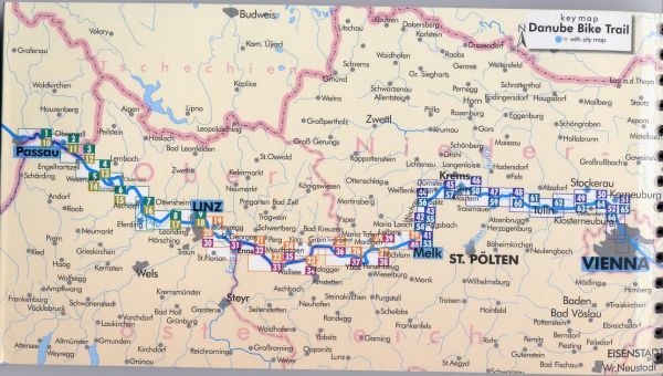
The route of the Danube bike path from Passau to Vienna
This map is taken from the guide book that nearly everyone we saw cycling on the path had on their handlebars.
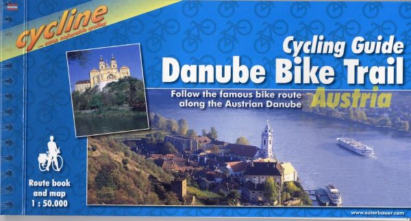
The Guide to the Danube Bike Trail
This guide is indispensible to anyone biking the Danube. It can be ordered over the Internet or bought anywhere along the bike path. I lost my copy during the trip and bought another (in English) at a tiny book store in a tiny town. They had a whole pile of them.
This guide book has detailed (1:50,000) maps of the entire route. That is, one centimeter equals a kilometer, or about one and a quarter inches to a mile. A typical page is shown below:
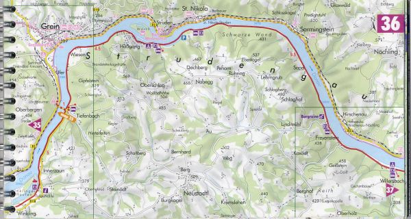
Typical page in the guide, showing about six miles of the route
The guide book has a ring binder and is sized to fit on a map holder or handlebar bag. I had a lot of trouble keeping mine mounted correctly, but that's another story.
In addition to the detailed maps, the guide book has listings of tourist attractions and descriptions of the route. However, it isn't perfect, and I spent a lot of time thinking about how it could be improved. One thing that was particularly frustrating was the division of maps and descriptions into left-bank and right-bank sections of the book. Unfortunately, the river divides the world into two disjoint halves. You can only cross the river on bridges or ferries that are irregularly spaced at about five mile intervals. So as you bike the constant question you are asking is: which side of the river is it better to be on here? While you are asking this question you are leafing back and forth to whole different sections of the guide, which tries usually to be completely agnostic on the question of which side is better.
One simple change they could make in the guide would be to have the maps use the same legend for both sides of the river. For example, the map page shown above (map 36) is for the right, or south, bank of the river. Consequently, the color codes of the path are only correct on that side of the river on this map. The purple coloring of the bike route along the river indicates that it is a dedicated bike path. But what about the path on the opposite side? Well, for that you have to turn to (you fumble around) map 25.
In addition to being non-judgmental about sides of the river, the guide is fairly non-judgmental about the relative attractiveness of the tourist attractions. For example, the monastery at Melk is a world-class attraction, but gets about the same coverage as very minor monuments. How are you to know?
Although the guide contains descriptions of the path, they seemed pretty useless ("After the gardens the path becomes quite narrow -- stay to the left of the tracks -- behind an old warehouse to the sidestreet -- after crossing the main road take the bicycle path towards Achleiten....") I can't imagine anyone actually reading this while biking, nor can I imagine any value in reading this before biking. In fact, both Len and I found that we couldn't actually read the guide before the trip. It just isn't something you sit down and read.
I don't mean to bash this guide too much. The maps are invaluable, and so are the numerous descriptions of attractions along the way.
Before cycling the path I had the idea that there was a straight, dedicated bike path on each side of the river for the entire length of the path. In my mind I saw this path stretching out to infinity. Well, it isn't so. There are runs of perhaps ten miles where you have an uninterrupted bike path, but soon the path runs into a road, and for a while you share the road with cars (always, however, a minor road). Then for a while the path might be a sidewalk adjoining a major highway. At other times the path would leave the river and circle through farms and orchards. It's probably better that way. Variety is the spice of life.
It's even possible to get lost, at least temporarily. Not only did Len and I have the detailed maps, but we both had GPSs mounted on our handlebars with good maps of the entire area. At all times we could see exactly where we were. Also the signs along the bike path are generally quite good. Moreover, all you have to do is follow the river. How could you go wrong? Nonetheless, Len and I found a way to make several wrong turns each day. We were never lost for long, though. One of us would observe that on the GPS we seemed to be heading the wrong direction. Retracing our route, we would find that we had missed a sign, or perhaps the sign itself was missing. Of course, these were always times when the route had left the river.
The following web pages will describe and show pictures of each successive day in the six-day trip.